Old representations of Galata
1400 - cristoforo buondelmonti
Cristoforo Buondelmonti (1386 - c. 1430) was an Italian Franciscan priest and traveler, and a pioneer in promoting first-hand knowledge of Greece and its antiquities throughout the Western world. He left his native city of Florence , around 1414 C.E. in order to travel, mainly in the Aegean Islands. He visited Constantinople in the 1420s. He is the author of two historical-geographic works: the Descriptio insulae Cretae (1417) and the Liber insularum Archipelagi (1420). These two books are a combination of geographical information and contemporary charts and sailing directions. The last one contains the oldest surviving map of Constantinople.
1410 - cristoforo buondelmonti hand manuscrit
Each representations as different buildings, update where often added in new copy, but also some of them where not correct...
1420 - cristoforo buondelmonti constantinople
Greek copy in an book writen in Latin (topkapi saray library)
1475 - Edition of Liber insularum Archipelagi Cristoforo Buondelmonti (from Dusseldorf library)
1490 - copy of buondelmonti map
This copy is empty inside the walls but as informations outside...
1493 - Hartmann Schedel
The Nuremberg Chronicle is a book published in Germany in 1493. It is a biblical paraphrase in the form of a universal chronicle including stories from several European cities. Written in Latin by Hartmann Schedel and it is one of the best documented and the best preserved and one of the first to successfully integrate texts and images.

1490 - plan of Vavassor
1550? - Pirî Reis (1470?-1554)
Part of the constantinople map with Galata/Pera area from "Kitab-i bahriyye" atlas book
1550 - Munster
Sebastian Münster or Sébastien Munster (born in 1488 in Ingelheim, died in 1552
in Basel) is a humanist scientist and cartographer from southern Germany. He was the author of the Cosmographia Universalis.
Most of these drawings where colored later...
 1572 - George Braun-Franz Hogenberg
From the very first atlas of city views. The work, originally published in Latin around 1572 under the title Civitates orbis terrarum, is the work of Georg Braun (1541-1622), geographer and publisher from Cologne, and Frans Hogenberg, cartographer born in Mechelen and died in Cologne around 1590.
we can see here informations about the doors of the city walls...and Saint Benoit church...
1572 - Constantinople map
Tommaso Porcacchi (1530?-1585)
from book : "L'isole piu famose del mondo". This edition is from 1620...source : BnF
 1572 - Camancio
1573 - pinargenti
1615 - beauvau
1654 - jaspar isac
Jaspar Isaac (Antwerp, 1585? - Paris, May 23, 1654)
is a French engraver and print dealer of Flemish origin.
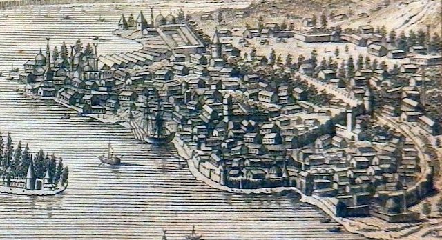
The vue is drawn from the top of the hill...so we can see the first set of the city wall without the Galata castle, witch was built later on...

1660 - Vue of Galata
From Daniel Meisner's book.
Vue from uphill showing the fortification around the christ tower
1684 - WAGNER
Detailed vue of Galata from uphill.
1686 - Pirî Reis (1470?-1554)
copy of representative vue of Galata (not in scale) from "Kitab i Bahriye"
1686 - Vogel, Johann Jakob
in Allain Manesson Mallets, Vol. 4, Issue Fig. 56
1719 version
1680 - Grelot
Guillaume-Joseph Grelot (1630 - 1680) had received from Louis XIV the mission to go to the Ottoman Empire, probably to collect coins, manuscripts as well as information about the country and society. Departing from Smyrna on July 1670 aboard a Turkish vessel, he arrived in Constantinople, after crossing the Dardanelles and following the northern coast of the Propontides.
1695 - Nicolas de Fer
DE FER , Nicolas (1646 - 1720)
Cartographer, engraver and publisher, Nicolas de Fer issued altogether rather more than 600 separate maps, including atlases, sheet maps and large wall maps.
We can see more buildings and churches details on the plan...
1705 - chatelain
CHATELAIN, Henri Abraham (1684 - 1743)
His atlas was published in seven volumes between 1705 and 1720. The maps were accompanied by information pertaining to cosmography, geography, history, chronology, genealogy, topography, heraldry, and costume of the world. The maps in the Atlas Historique were mainly based on those of the French cartographer, Guillaume De L’Isle.
 1711 - Banduri - from bueldelmonti
Anselmo Banduri (1675-1743)
Italien, Bénédictin, Archéologue and numismate...from his book : "Imperium orientale, sive Antiquitates Constantinopolitanae in quatuor partes distributae" two volume. this edition is from 1729.
1711 - Banduri
Very detailed synthesis plan of the city...copy from Grelot

1789 - later vue of Galata from Spanish publication of Vista


